Introduction
You're walking a low-lying corner of your property after a wet spring — the ground sponges underfoot, cattails ring the edge, and you're not sure whether that area qualifies as a wetland or just soggy soil. The distinction matters more than most landowners realize.
Wetland delineation is the formal, field-based process that draws the legal line between wetland and upland. Get it wrong — or skip it entirely — and you're looking at permit denials, mandatory site restoration, and civil penalties that can reach $27,500 per day per violation under the Clean Water Act.
This article covers what wetlands are, how the delineation process works, what the law actually requires, and what landowners and farmers should do once they have a delineation in hand. Whether you're planning a drainage improvement, expanding crop acres, or simply trying to understand what you own, knowing where regulated wetlands begin and end is where that process starts.
Key Takeaways
- Wetland delineation maps the legal boundary between wetland and upland using soil, vegetation, and hydrology data
- Section 404 of the Clean Water Act requires a delineation before you fill, drain, or build near regulated wetlands
- The 2023 Sackett v. EPA ruling narrowed federal jurisdiction — but Wisconsin and many other states maintain independent protections that still apply
- Approved delineations are valid for five years under USACE guidelines
- Cost varies by site size — but it's far less than the fines for skipping it
What Is a Wetland — And Why These Ecosystems Matter
Defining Wetlands (and What They're Not)
Wetlands are areas where land is permanently or seasonally saturated by water — think swamps, marshes, bogs, fens, and vernal pools. But not every soggy patch qualifies. Legal wetland classification requires specific indicators across soil, plant life, and hydrology. That distinction carries real consequences for what you can and can't do with your land.
Ecologically, wetlands punch well above their weight. A single acre can store up to 1.5 million gallons of floodwater, making them critical infrastructure in flood-prone agricultural landscapes. They also filter nutrients, sequester carbon, and support more than one-third of all U.S. threatened and endangered species, many of which rely on wetlands exclusively.
Why Farmers Should Pay Attention
For working farms, wetlands aren't just a regulatory complication — they're functional assets. Research from the USDA Natural Resources Conservation Service shows that restoring just 6% of a cultivated crop field to wetland can reduce dissolved nitrogen losses by 29% and dissolved phosphorus losses by 28%. At the Mississippi Basin scale, targeted wetland restoration of just 22% of degraded areas could cut nitrate loading to the Gulf of Mexico by more than half.
Beyond nutrient filtration, wetlands support farm operations in ways that rarely show up on a balance sheet:
- Recharge groundwater that feeds crops during dry stretches
- Buffer fields from flood damage during high-precipitation events
- Anchor watershed health across entire farming regions
The Loss Context
The U.S. has already lost 53% of its original wetland acreage — from an estimated 221 million acres in the 1780s down to about 103 million acres by the mid-1980s, according to the U.S. Fish & Wildlife Service. That scale of loss is what drove the regulatory frameworks — and the delineation requirements — that landowners and farmers navigate today.
What Is Wetland Delineation?
Wetland delineation is the field-based process of determining the precise legal boundary between a wetland and the adjacent upland on a specific property. It goes beyond a map review or visual inspection: it involves on-site sampling, documentation, and a formal report submitted to regulatory agencies.
Delineation vs. Reconnaissance
These two terms get confused often, and the distinction matters:
- Wetland reconnaissance is a preliminary screening — a desktop review combined with a site walk to gauge whether a regulated feature likely exists. It doesn't produce a legal determination.
- Wetland delineation is the full process: field sampling, boundary flagging, GPS mapping, completed data forms, and a formal written report. This is what regulatory agencies require.
Who Performs Delineations
Delineations must be conducted by qualified environmental scientists or ecologists trained in U.S. Army Corps of Engineers (USACE) methods.
In Wisconsin, the DNR's Assured Wetland Delineator (AWD) program matters for project timelines: delineations by AWD-recognized professionals proceed without mandatory DNR field verification. For Wisconsin landowners, hiring from the DNR's assured delineator contact list is the most direct way to avoid verification delays.
What the Final Report Looks Like
Once fieldwork wraps up, the delineator compiles a formal report that includes:
- GPS-mapped wetland boundary with flagged field markers
- Completed USACE data forms documenting soil, vegetation, and hydrology at each sampling point
- A formal written report submitted for agency review and jurisdictional determination
The Three-Parameter Approach: How Wetland Boundaries Are Determined
The USACE 1987 Wetland Delineation Manual established a "three-parameter" method that remains the national standard. For an area to qualify as a jurisdictional wetland, all three indicators must be present. An area missing even one indicator falls outside wetland classification.
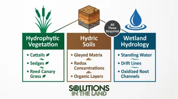
Hydrophytic Vegetation
Hydrophytic plants are adapted to survive in saturated, low-oxygen soils. Delineators survey which species dominate each area and classify them using the USACE National Wetland Plant List : obligate wetland, facultative wetland, or facultative species. When these dominate, the vegetation parameter is met.
Common examples in the Midwest include cattails, sedges, reed canary grass, and buttonbush. Soil conditions tell the next part of the story.
Hydric Soils
Hydric soils form when ground stays saturated long enough to deplete oxygen — a condition that leaves chemical fingerprints. Delineators use a soil auger to collect samples and a Munsell color chart to identify:
- Gleyed matrices — gray or blue-green coloration from iron reduction
- Redox concentrations — rust-colored mottling around root channels
- Organic surface layers — dark, decomposed organic matter near the surface
These features indicate prolonged anaerobic conditions, even if the site appears dry at the time of sampling.
Wetland Hydrology
This parameter confirms that the site floods or saturates long enough during the growing season to drive the soil and vegetation conditions observed. Delineators look for:
- Primary indicators — standing water or saturated soils in the upper soil profile
- Secondary indicators — water-stained leaves, drift lines, moss trim lines on trees, oxidized root channels
At least one primary indicator — or two secondary indicators — must be documented to satisfy this parameter.
The Legal Framework: When Wetland Delineation Is Required
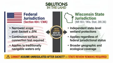
Federal vs. State Jurisdiction
Wetlands are regulated federally under Section 404 of the Clean Water Act as part of the "Waters of the United States" (WOTUS). The 2023 Sackett v. EPA Supreme Court ruling narrowed that federal scope considerably, adopting a "continuous surface connection" test that may have removed federal protection from a significant share of U.S. wetlands — particularly isolated wetlands not physically connected to navigable waters.
State protections remain fully in force regardless. Wisconsin's independent framework — including Chapter NR 103 and Wis. Stat. Section 281.36 — continues to regulate wetland impacts regardless of federal jurisdiction. Landowners cannot assume a wetland is unregulated simply because it falls outside post-Sackett federal reach. A qualified delineator evaluates both layers before any site work begins.
Common Triggers for a Required Delineation
A delineation is typically required before any of the following:
- Filling or draining agricultural fields
- Land development or construction activity
- Road-building or placing fill material
- Major grading near low-lying or saturated areas
- Any project that could discharge material into a regulated water or wetland
Proceeding without a required delineation exposes landowners to civil penalties up to $27,500 per day per violation under CWA Section 309(d), plus potential restoration mandates.
Validity Period
An approved jurisdictional determination is valid for five years under USACE Regulatory Guidance Letter 05-02. After that, changed site conditions may require re-delineation, which is worth factoring into any phased development schedule from the start.
What Comes After Delineation: Mitigation and Compliance Options
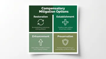
If a project unavoidably impacts a regulated wetland, the EPA and USACE require compensatory mitigation — the landowner must offset the loss through one of four pathways:
| Mitigation Type | What It Means |
|---|---|
| Restoration | Re-establishing a previously existing wetland |
| Establishment | Creating a new wetland where none existed |
| Enhancement | Improving ecological function in an existing wetland |
| Preservation | Permanently protecting an ecologically significant wetland |
For landowners who don't want long-term ecological stewardship responsibility, the mitigation bank alternative is often more practical. Purchasing credits from an approved wetland mitigation bank transfers the legal obligation to the bank sponsor. The U.S. currently has approximately 2,000 approved mitigation banks covering nearly 1 million acres — and bank credits represented the mitigation solution in 92% of cases from 2015 to 2024.
Regulators aren't trying to halt land use — the goal is to ensure impacts are minimized and offset in a measurable way. Approached early with qualified professionals, compliance is a workable process, not a roadblock.
Wetland Delineation and the Bigger Picture of Sustainable Land Stewardship
For farmers and landowners, a wetland delineation delivers something more useful than regulatory compliance. Knowing which portions of a property are subject to seasonal saturation directly shapes decisions like:
- Drainage planning — where tile lines make sense and where they don't
- Field boundaries — avoiding investment in areas that can't be farmed legally
- Grazing rotations — keeping livestock out of saturated areas that need protection
- Crop planning — matching production systems to actual soil and hydrology conditions
Site-specific hydrology data like this is what separates reactive land management from deliberate, long-term farm planning. Solutions in the Land, based in Kenosha, WI, builds whole-system farm plans that incorporate water management features — tiles, sinks, seasonal hydrology — alongside production goals and regulatory constraints. The result is a plan grounded in what a property can actually do, not what a landowner assumes it can.
For anyone navigating wetland-related decisions as part of a farm transition or land acquisition, that kind of integrated planning often reveals options that compliance-only thinking misses entirely.
Frequently Asked Questions
What does wetland delineation mean?
Wetland delineation is the professional process of identifying and mapping the precise legal boundary between a wetland and the surrounding upland on a specific property. It's based on three field-evaluated indicators — hydrophytic vegetation, hydric soils, and wetland hydrology — established by the USACE.
Do I need a wetland delineation?
A delineation is legally required before any project that could impact a regulated wetland, including filling, draining, building, or major grading. Proceeding without one when required can result in significant daily fines and mandatory site restoration.
How do I know if I have wetlands on my property?
Preliminary signs include persistently soggy or low-lying areas, distinctive sulfur-like soil odors, and water-tolerant plants like cattails or sedges. The USFWS National Wetlands Inventory Mapper is a useful starting point, but it doesn't substitute for a formal delineation.
How is a wetland delineation done?
A trained professional evaluates all three parameters — vegetation, soils, and hydrology — at sampling points across the site, flags the wetland boundary, and prepares a formal report for regulatory submission. The USACE 1987 Manual governs the methodology.
How long does a wetland delineation take?
Timeline varies with site size and complexity. Small sites may take a few days of fieldwork; larger or more complex properties can take several weeks once fieldwork, reporting, and agency review are factored in.
How much does wetland delineation cost?
Costs vary based on acreage, terrain, wetland complexity, and region. Small sites under 5 acres typically run $1,500–$5,000; larger or more complex properties can exceed $10,000. These figures come from environmental consulting firms, not federal agencies — get multiple quotes.