The challenge is that most landowners have no structured way to evaluate what's actually happening on their property. Soil biology, watershed function, habitat quality, biodiversity — these systems interact constantly, yet most farm management decisions get made without a clear picture of any of them.
This guide covers what ecological assessment is, why it matters in agriculture, the core methods used, and how to work through the process systematically — so your land management decisions are grounded in real conditions rather than assumptions.
Key Takeaways
- Ecological assessment evaluates a landscape's biological and physical conditions — soil, water, habitats, and species — to guide informed land management decisions.
- Assessment types range from rapid walkover surveys to full quantitative evaluations, depending on land use goals and scale.
- Methods span habitat mapping, soil biological sampling, indicator species surveys, and GIS spatial analysis.
- Findings translate directly into action: grazing system design, conservation program applications, restoration priorities, and risk mitigation.
- Working with agronomists and land consultants ensures ecological data shapes decisions that are both environmentally sound and economically viable.
What Is an Ecological Assessment?
The EPA defines ecological risk assessment as "the application of a formal process to (1) estimate the effects of human action(s) on a natural resource, and (2) interpret the significance of those effects in light of the uncertainties identified in each phase of the assessment process."
In plain terms: it's the formal method for understanding how human activities shape land conditions — and what that means for an ecosystem's long-term function. The right assessment approach depends entirely on what question you're trying to answer.
Assessment Types: From Qualitative to Quantitative
Not all ecological assessments look the same. The appropriate type depends on your land use goals, the complexity of the property, and what decisions the assessment needs to support.
- Rapid/qualitative assessments — evaluate visible indicators like vegetation cover, soil structure, and erosion signs through walkover surveys; practical for initial farm planning
- Quantitative soil health assessments — structured sampling of biological, chemical, and physical soil indicators using tools like the NRCS Soil Quality Test Kit or laboratory analysis
- Targeted species surveys — focused observation for specific indicator groups (pollinators, breeding birds, amphibians) tied to ecosystem health questions
- Landscape-scale GIS assessments — spatial analysis integrating aerial imagery, soil maps, and watershed data to surface patterns invisible at the field level
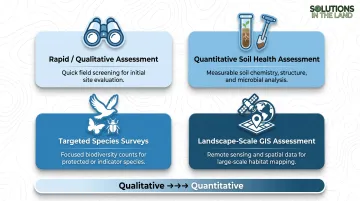
In agricultural contexts, assessments typically focus on soil health, watershed function, habitat quality, and biodiversity — not development compliance.
Ecological Assessment vs. Environmental Impact Assessment
This distinction confuses many landowners. In the US regulatory context:
- An ecological assessment focuses on the biological and physical condition of a specific landscape — habitats, species, soil function, and water systems
- An Environmental Impact Assessment (EIA) is a broader statutory process under NEPA covering ecology alongside air quality, noise, traffic, and cultural impacts — typically required for major infrastructure projects, not routine agricultural land management
For most farmers and landowners, ecological assessment is a voluntary planning tool. EIAs are primarily reserved for federal actions with significant environmental consequences — knowing the difference helps you choose the right tool before committing time or resources.
Why Ecological Assessment Matters for Landowners and Farmers
Without knowing what's on your land — which species use it, how your soils are functioning biologically, where water moves and collects — you cannot make sound decisions about crop systems, grazing rotations, conservation investments, or land transitions. Ecological assessment provides that baseline.
The Economics of Ecological Health
According to the Soil Health Institute's 100-farm study across nine Midwest states, the economics of soil health are hard to argue with:
| Metric | Corn | Soybeans |
|---|---|---|
| Farmers reporting increased net income | 85% | 88% |
| Average net income gain per acre | $52 | $45 |
| Average cost-to-grow reduction per acre | $24 | $17 |
| Increased resilience to extreme weather | 97% | 97% |

The flip side is just as stark. USDA Agricultural Research Service data shows the US loses approximately $44 billion annually from soil erosion alone. Degraded soil biology, fragmented habitats, and disrupted hydrology suppress farm productivity — often without visible warning until crop yields start to drop.
Access to Federal Conservation Programs
Ecological assessment isn't just an environmental exercise — it's a financial tool. USDA programs like EQIP, CRP, and RCPP all require or reward applicants who can document existing land conditions and articulate specific, measurable improvement targets.
For EQIP specifically, applicants must:
- Submit a conservation plan that addresses identified resource concerns
- Demonstrate compliance with highly erodible land (HEL) and wetland conservation provisions
- Document existing land conditions to strengthen competitive ranking scores
Baseline ecological data doesn't just satisfy requirements — it separates competitive applications from weak ones.
Legal Risk Reduction
Ecological assessment converts unknown regulatory exposure into manageable, documented conditions. Two specific risk areas:
- Clean Water Act Section 404: Normal farming activities are exempt from permit requirements, but converting a wetland to a new agricultural use requires a permit. Without knowing where wetland boundaries sit on your property, you're exposed.
- Endangered Species Act: Knowing violations carry civil penalties up to $25,000 per violation; criminal violations can result in fines up to $50,000 and/or imprisonment. An ecological assessment that identifies protected species habitat before you make land management changes provides a critical defensive baseline.
Key Methods Used in Ecological Assessments
Habitat and Vegetation Surveys
The starting point for nearly every agricultural land assessment. A qualified assessor walks the property, maps land cover types, identifies plant communities, notes invasive species pressure, and flags areas of ecological sensitivity. This walkover survey produces the spatial foundation that every subsequent method builds on.
Soil Health and Biological Indicator Sampling
In an agricultural context, meaningful soil assessment goes beyond standard nutrient testing. NRCS identifies five key biological indicators that reflect actual soil function:
- Earthworms: indicator of biological diversity, water regulation, and nutrient cycling
- Soil respiration: measures microbial activity and organic matter decomposition
- Particulate organic matter (POM): reflects carbon storage and biological diversity
- Potentially mineralizable nitrogen (PMN): estimates available nitrogen and nutrient cycling capacity
- Soil enzymes (such as beta-glucosidase): indicate residue decomposition rates
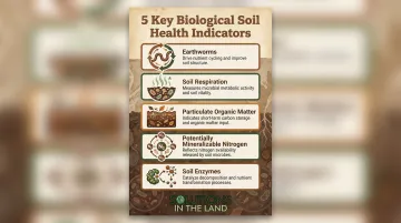
These indicators inform decisions about cover cropping, adaptive grazing, and organic transitions in ways that a basic soil chemistry panel never could.
Targeted Species Surveys
Indicator species reveal things about ecosystem health that vegetation surveys miss. Three species groups deliver particularly reliable signals:
- Pollinators — a recognized ecosystem function indicator; NRCS notes one-third of US agricultural output depends on them, with crops like blueberries and cherries up to 90% dependent on honey bee pollination
- Breeding birds — surveys during nesting periods (primarily early-to-mid June) provide population trend data reflecting landscape-scale habitat quality
- Amphibians and fish — presence in riparian zones indicates water quality and habitat connectivity
GIS Mapping and Spatial Analysis
Field observations show what's happening at a point in time, in a specific location. GIS layering reveals the bigger picture: fragmented wildlife corridors, erosion-prone topography, floodplain encroachment, watershed-scale hydrology. Three free federal tools provide the desk-study foundation:
- USDA Web Soil Survey — covers 95%+ of US counties; queryable by soil properties, agricultural suitabilities, and conservation practice limitations
- USGS StreamStats — delineates drainage areas and estimates flow statistics for watershed-scale hydrology
- USGS National Hydrography Dataset — comprehensive stream, river, lake, and wetland mapping
How to Conduct an Ecological Assessment: Step by Step
Ecological assessments in agriculture follow consistent logic even when specific tools vary by property. Shortcuts at any stage reduce the reliability of the whole process.
Step 1: Define Scope and Assessment Goals
Identify why the assessment is being conducted. The purpose shapes everything: what data gets collected, at what depth, and at what cost.
Common triggers include:
- Conservation program application (EQIP, CRP, RCPP)
- Grazing system redesign or adaptive management transition
- Organic certification pathway
- Voluntary ecological baseline before a land transaction or easement
Step 2: Desk Study and Baseline Data Collection
Before stepping foot on the property, gather existing information:
- Soil survey data from USDA Web Soil Survey
- Watershed and hydrology maps from USGS StreamStats and NHD
- State natural heritage database records for rare or protected species
- Aerial imagery history showing land use changes over time
- Known stressors: previous pesticide use, tile drainage networks, overgrazing history
This phase defines the ecological context and guides what field surveys need to prioritize.
Step 3: Field Surveys and On-Site Data Collection
Conduct walkover habitat mapping, soil sampling across ecological zones, and targeted species observations. Timing matters here:
- Breeding bird surveys must occur during nesting periods (early-to-mid June)
- Soil biology sampling should avoid drought or frost extremes — biological activity indicators are sensitive to soil moisture and temperature conditions
- Pollinator and amphibian surveys are season-specific and require coordination with species activity windows
Surveys conducted outside optimal windows miss critical data and produce unreliable baselines.
Step 4: Analysis and Ecological Interpretation
Synthesize field and desk data to assess ecological condition across land areas. Effective interpretation integrates:
- Abiotic indicators: soil chemistry, compaction, hydrology, erosion risk
- Biotic indicators: vegetation diversity, wildlife presence, pollinator populations, invasive species pressure
The result is a habitat quality rating, a soil function assessment, and a mapped breakdown of priority areas — those needing immediate intervention and those with conservation or production potential.
Step 5: Develop Recommendations and an Action Plan
A well-structured management plan translates ecological data into land investment decisions. It identifies:
- Immediate interventions: invasive species removal, riparian buffer restoration, soil compaction remediation
- Conservation enrollment candidates: areas that qualify for EQIP, CRP, or other program cost-share
- Production improvement zones: locations suited for regenerative grazing rotations or cover cropping systems
- Monitoring priorities: indicators to track over time to measure ecological recovery
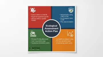
The final deliverable is a prioritized, property-specific action plan with clear land management goals — something landowners and farmers can act on immediately.
How Solutions in the Land Can Help
Solutions in the Land, based in Kenosha, WI, integrates ecological assessment as a foundational step within its whole-system farm planning process. Before recommending grazing systems, crop transitions, or organic certification pathways, the team works through a comprehensive evaluation of each client's property covering current conditions, land history, watershed context, and ecological constraints — to ensure every recommendation is grounded in real conditions rather than generic best practices.
The process involves working through 143 questions about a farm, structured across six areas: Guiding Principles, Regional Context, Current Conditions, Opportunities & Constraints, Recommendations, and Revenue Generators. The Current Conditions phase specifically inventories factors beyond apparent soil fertility , including tile drainage, sinks, utility easements, and other subsurface and regulatory considerations that affect land function and risk.
In their framing, ecological assessment is a strategic investment — one that tells you what your land is actually doing before you commit to what comes next.
Frequently Asked Questions
What is the ecological assessment process?
Ecological assessment follows a structured sequence: define scope and goals, conduct a desk study using existing soil and species data, complete field surveys across ecological zones, analyze biological and physical indicators together, and produce a management plan with prioritized recommendations. The depth of each phase varies based on land type and project goals.
What is the meaning of ecological assessment?
Ecological assessment is the systematic evaluation of a landscape's biological and physical condition (habitats, soil health, water systems, and species) to understand how the land is currently functioning and what changes in management would improve or protect it.
What is the difference between EIA and EcIA?
An EcIA (Ecological Impact Assessment) focuses specifically on how a project affects habitats and species. An EIA (Environmental Impact Assessment) is a broader statutory process covering ecology alongside air quality, noise, traffic, and cultural impacts. In the US, EIAs are required under NEPA for major federal actions — not routine agricultural land management.
Are EIAs legally required for farmers?
Generally no. NEPA applies to major federal actions, and routine agricultural activities typically fall under categorical exclusions. Ecological assessments for agricultural land management are usually voluntary or required for specific USDA conservation program applications, not triggered by NEPA compliance.
What is an ecological assessment report?
An ecological assessment report documents the methods used, data collected, ecological conditions found, and recommended management actions. It serves as both a baseline record of the land's condition and a practical guide for future decisions. Many conservation program applications also require one.
What is an example of an ecological assessment in agriculture?
A landowner transitioning from row crops to a regenerative grazing system commissions an ecological assessment. The process maps soil health zones across the property, identifies degraded riparian buffers, flags invasive species encroachment, and recommends targeted restoration actions alongside specific grazing rotations. The result gives the transition plan a clear, documented ecological foundation.